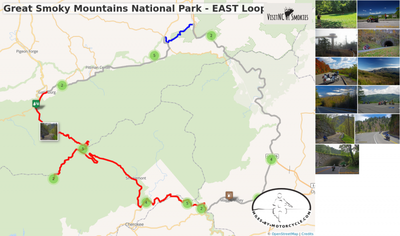
Great Smoky Mountains National Park - EAST
A loop ride around the east side of Great Smoky Mountains National Park.
Distance: 115 miles
Ride Time: 4-6 hours
START: Maggie Valley
- Follow US 19 - Soco Road west and climb to the Blue Ridge Parkway
7.4 Miles
- Get on the Blue Ridge Parkway at Soco Gap. Follow the Blue Ridge Parkway towards Cherokee for 13.5 miles.
20.9 Miles
- Turn right onto US 441 - Newfound Gap Road and cross Great Smoky Mountains National Park. Follow into Gatlinburg.
52.8 Miles
- Veer right onto US 321 - East Parkway Road. Ride along the north border of the park to US 321 at Cosby.
70.9 miles
- Turn left onto US 321 - Cosby Road and ride north to the Foothills Parkway entrance.
72.7 Miles
- Cruise the Foothills Parkway
78.3 Miles
- Leave the Foothills Parkway and ride south on I-40
107.6 Miles
- Exit I-40 @ Exit 20 onto US 276 and ride to US 19 - Soco Road
113.28 Miles
- Veer left onto US 19 - Soco road to complete the loop
114.2 Miles
END: Maggie Valley
START: Maggie Valley
Ride: Maggie Valley to Gatlinburg
- From the Haywood Visitor Center follow US 19 - Soco Road to Soco Gap and the entrance to the Blue Ridge Parkway. Get on the parkway heading towards Cherokee. This final section of the Parkway decends to Cherokee and the south entrance to Great Smoky Mountains National Park. Soon after entering the park you pass the Oconaluftee Visitor Center, a likely place to see some of the parks resident elk herds. Begin the climb on US 441 - Newfound Gap Road - South along the Oconalufftee River. You'll encounter numerous historic sights and viewpoints as the road winds to the summit at Newfound Gap. From this gap, Clingman's Dome Road spurs 7 miles to the highest point in Tennessee, a nice side trip to the tower atop the mountain. US 441 - Newfound Gap Road - North continues across the park Gatlinburg passing Sugarlands Visitor Center on the ride.
Ride: Gatlinburg to Maggie Valley
- Cruise east from Gatlinburg on US 321 - East Parkway Road to Cosby. Veer north on US 321 - Cosby Highway to the Tennessee Foothills Parkway - East. Ride through the Tennessee Foothills Parkway - East to Interstate Highway 40. I-40 runs south through the Tennessee River Gorge. Exit I-40 at Exit 20 onto US 276 - Jonathan Creek Road and follow to US 19 - Soco Road. US 19 leads to the Visitor Center.
END: Maggie Valley
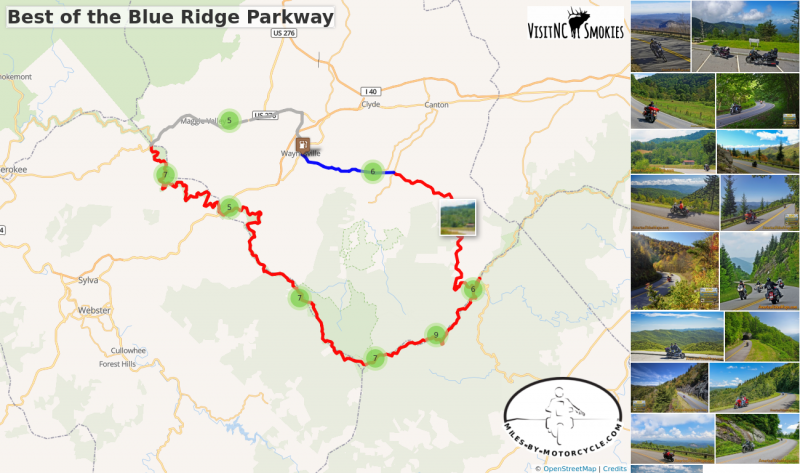
The Best Section of the Blue Ridge Parkway
Soco Gap ( Milepost 455.7) to Wagon Road Gap (Milepost 412.2)
Haywood County’s crowning jewel is the BEST section of the Blue Ridge Parkway. Arcing along the peaks on our southern border, this is the highest and most scenic portion of the 469 mile long ride.
Enjoy views from the highest point, see the Devil’s Courthouse, Looking Glass Rock, Graveyard Fields, and more.
Distance: 78 miles to make the loop
Ride Time: 3 hours or more
START: Maggie Valley
- Follow US 19 - Soco Road west and climb to the Blue Ridge Parkway
7.4 Miles
- Get on the Blue Ridge Parkway at Soco Gap. Follow the Blue Ridge Parkway towards Asheville for 43.3 miles.
51.2 Miles
- Exit the Blue Ridge Parkway at US 276 - Wagon Road Gap. Follow US 276 for 20.7 miles to Waynesville
72 Miles
- Pass through Waynesville on US 276 to US 19.
74.5 Miles
- Turn west on US 19 - Dellwood Road and follow to Maggie Valley
78 Miles
END: Maggie Valley
START: Maggie Valley
Ride: Maggie Valley to the Blue Ridge Parkway
- From the Haywood Visitor Center follow US 19 - Soco Road to Soco Gap and the entrance to the Blue Ridge Parkway. Get on the parkway heading towards Asheville.
Ride: Soco Gap to Balsam Gap
- MP 452.1 Cranberry Ridge Overlook - nice views towards Cherokee
- MP 451.2 Waterrock Know Overlook - visitor center, panoramic views from top
- MP 450.2 Yellow-Face Overlook - long range views over valley
- MP 445.2 Mt Lynn Lowery Overlook - View Mt. Lyn Lowery cross on top, Woodfin Cascades across valley
- MP 443.1 - Balsam Gap - US 74
Ride: Balsam Gap to Beech Gap
- MP 439.7 Pinnacle Ridge Tunnel
- MP 431.4 Richland Balsam Overlook - Highest point on the Blue Ridge Parkway
- MP 430.7 Cowee Mountains Overlook - nice panoramic views
- MP 428 Caney Fork Overlook - Panoramic views
- MP 423.5 Courthouse Valley Overlook - Nice views, good rest stop
- MP 423.3 Beech Gap - NC 215
RIde: Beech Gap to Wagon Road Gap
- MP 422.4 Devil's Courthouse Overlook - View from base of rock formation and valley below
- MP 422.1 Devil's Courthouse Tunnel
- MP 418.8 Graveyard Feilds Overlook - popular stop with waterfalls, parking gets congested
- MP 418.3 Looking Glass Rock Overlook - Popular stop, good views of rock formation
- MP 413.2 Pounding Mill Overlook - panoramic views from point
- MP 412.9 Cold Mountain Overlook - Good rest stop near exit, views
- MP 412.2 Wagon Road Gap - Junction with US 276
Ride: Blue Ridge Parkway to Maggie Valley
- The drop from the parkway on US 276 - Cruso Road is a thrill. It then winds through the forest for several mailes and emerges along the Pigeon River as it flows towads the Bethel valley. US 276 - Pigeon Road takes you through Pigeon Gap into downtown Waynesville. Follow Main Street then US 276 - Russ Avenue to the junction with US 19. Follow US 19 - Dellwood Road back to Maggie Valley.
END: Maggie Valley
Best of the Blue Ridge Parkway
This 43 mile section is the best of the 491 mile long ride. It's the highest, the most scenic and has more overlooks to enjoy it.
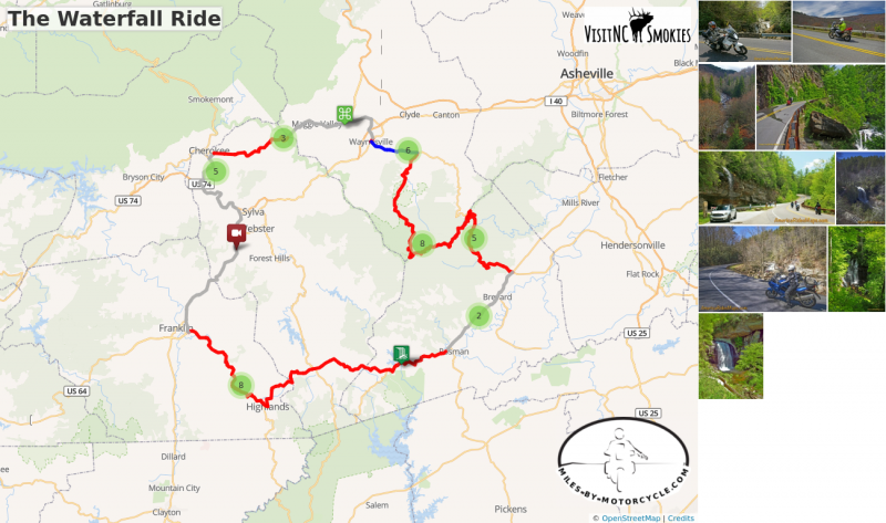
The Waterfall Ride
Tour almost a dozen roadside waterfalls on this scenic day ride.
Distance: 165 miles
Ride Time: All day ride
Difficulty: Easy to moderate difficulty
Start: Maggie Valley
- Starting at the Haywood Visitor Center, follow US 19 - Soco Road west.
7.3 Miles
- Pass under Blue Ridge Parkway at Soco Gap and continue on US 19 - Wolftown Road
8.9 Miles - Soco Falls
- Gravel pull off on left with small signs on the downhill section of US 19 on a sharp curve. The falls can’t be seen from road. A path and boardwalk lead to an overlook with 2 converging waterfalls.
18 Miles
- Continue on US 19 into Cherokee. Turn left @ traffic light onto Casino Road to cut to US 441 south.
18.8 Miles
- Turn left @ traffic light onto US 441 south to leave Cherokee and merge onto US 74 east (Exit 74).
21.6 Miles
- Follow US 19 / 74 / 441 (Great Smoky Mountains Expressway) east to Dillsboro.
29.5 Miles
- Leave the highway at Exit 81, pass Dillsboro and continue south. Follow US 441 south to Franklin.
47.3 Miles
- Exit US 441 and follow NC 28 / US 64 east. NC 28 leads into the Cullasja Gorge.
52.6 Miles - Cullasaja Falls
- Visible from road on right. Limited and hazardous parking near guardrail on sharp curve.
57.4 Miles - Quarry Falls
- Visible from road on right. Long paved pulloff on right side of road.
60.7 Miles - Dry Falls
- Not visible from road. Paved parking on right with signs. Short trail to waterfall. Path continues behind waterfall.
61.4 Miles - Bridal Veil Falls
- Visible from road on left. Paved pull off. Drive behind the waterfall for a photo.
64.2 Miles
- Turn left @ traffic light in Highlands to continue on US 64.
86.7 Miles - Toxaway Falls
- Not visible from road. Road crosses dam with waterfall below. Difficult to get a good view. Park at Toxaway Village or along road on dam.
- Continue on US 64 east past Rosman and through Brevard
106.2 Miles
- Turn left @ traffic light onto US 276 north. Ride north into the Pisgah Forest.
111.9 Miles - Looking Glass Falls
- Visible from road. Large paved parking along road on right. Boardwalk to base of falls.
114 Miles - Sliding Rock
- Not visible from road. Fee area $2. Paved parking lot. Bathers slide down waterfall. Continue climbing on US 276 to the Blue Ridge Parkway.
121.2 Miles
- Turn right onto parkway ramp. Turn left at the stop sign to head south (towards Cherokee) on the Blue Ridge Parkway.
128.2 mi - Second Falls
- Graveyard Fields - Not visible from road. 1/3 mile paved walk to top of Second Falls. Trails continue to 2 others.
132.9 Miles
- Exit Parkway. Turn left (towards Canton) on NC 215. Descend from the parkway on NC 215.
134.8 Miles - Bubbling Spring Falls
- Visible from road. Hard to find. Look for 3rd gravel pull out on right on the only straight section of road.
137.2 Miles - Sunburst Falls
- Visible from road on left. River plunges beneath the roadway on a hairpin curve. Small unpaved parking are just beyond. Follow NC 215 - Lake Logan Road to US 276.
150.2 Miles
- Turn left @ stop sign to follow US 276 into Waynesville.
155.8 mi
- Turn right @ traffic light in Waynesvile. Pass through town on Main Street.
156.25 Miles
- turn left onto US 276 - Russ Avenue. Follow to US 19.
158.7 Miles
- Turn left onto US 19 - Dellwood Road. Follow to Visitor Center
162.09 Miles
END: Maggie Valley
Start: Maggie Valley
Ride: Maggie Valley to Franklin
-
Follow US 19 - Soco Road west and climb to Soco Gap. Pass under the Blue Ridge Parkway and start dropping from the heights on US 19 - Wolftown Road. Ride through a long passing lane then hook around a curve. The unpaved parking area for Soco Falls is located on the next sharp turn.
- Leaving Soco Falls wind down to Cherokee on US 19 - Wolftown Road. When you get to Harrah's Cherokee Casino, turn left onto Casino Road to cut to US 441-S. Turn left onto US 441-S and follow to Exit 74 EAST onto US 74 / 441. Follow to Dillsboro Exit 81 south to Franklin. From Dillsboro, ride south 18 miles on US 23 / 441 - Sylva Road to NC 28 / US 64 - Highlands Road in Franklin.
Ride: Franklin to Brevard
-
NC 28 / US 64 - Highlands Road rolls out from Franklin along the Cullasja River through gentle country then quickly turns sharp when reaching the Cullasaja River Gorge. You'll encounter four nice roadside waterfalls as NC 28 twists into Highlands. Turn north on US 64 - Rosman Highway in Highlands and follow to Cashiers. You'll pass Toxaway Falls as the road continues to Rosman. US Highway 64 run seast from Rosman through buslting Brevard. Follow through to the intersection with US 276 - Pisgah Highway.
Ride: Brevard to Maggie Valley
-
US 276 - Pisgah Highway leads north along the Davidson River into a very popular area of the Pisgah Forest. It's a pretty ride but expect congestion on nice weekends. Looking Glass Falls is the noteable attraction here, worth a stop for a closer look and a photo. Soon after you'll pass Sliding Rock. The road gently climbs higher and higher through pleasant twists. The higher you get the steeper the grade and the turnns grow progressively sharper. Arrive at the Blue Ridge Parkway junction at Wagon Road Gap at the top of the climb. The Cold Mountain Overlook is a good rest stop.
-
Ride the Blue Ridge Parkway south towards Cherokee. You'll pass the Graveyard Feilds Overlook with it's large and busy parking area. Second Falls is located here. Exit the Blue Ridge Parkway at Beech Gap onto NC 215 - Lake Logan Road.
- NC 215 - Lake Logan Road drops from the Parkway passing Bubbling Springs Falls and then Sunburst Falls. It winds and twists down to Bethel where it meets US 276 - Pigeon Road. US 276 - Pigeon Road takes you through Pigeon Gap into downtown Waynesville. Follow Main Street thenUS 276 - Russ Avenue to the junction with US 19. Follow US 19 - Dellwood Road back to Maggie Valley.
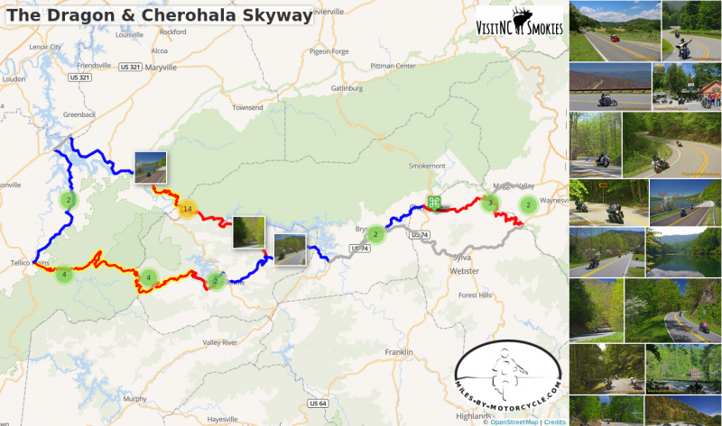
The Dragon & Cherohala Skyway
The Dragon, a.k.a. Tail of the Dragon is one of the most famous motorcycle rides in the world. This ride takes you there from Maggie Valley, then makes a loop into Tennessee to enjoy the fabulous Cherohala Skyway.
Distance: 67 miles to The Dragon
Ride Time: 1 1/2 hours
Distance to ride the loop: 250 miles
Ride TIme: All day ride
START: Maggie Valley
- Follow US 19 west, climb to the Blue Ridge Parkway.
4.1 Miles
- Pass under Blue Ridge Parkway. Continue through Cherokee to Bryson City.
26.3 Miles
- Turn right, then left at the traffic lights in Bryson City to continue on US 19 west.
29.4 Miles
- Merge onto Highway 23 / 74 and continue west. Junction US 19 / Alarka Road / Highway 23 / 74 Exit 64.
34.9 Miles
-
Veer right to continue NC 28.
46.3 Miles
- Junction NC 28 / NC 143. Continue on NC 28. Note this junction, this is where the loop returns to.
56.3 Miles
- Turn left @ stop sign on NC 28. Road to right leads to Fontana Dam.
66.7 Miles
- Turn right @ stop sign to ride the Dragon. Junction US 129 (The Dragon) and NC 28. Motorcycle Resort here. Food, gas, t-shirts, etc.
Ride the Dragon (US 129).
To continue on loop ride -
- Continue north to Punkin Center.
88.7 Miles
- Turn left onto TN 72. Follow to Vonore.
97.7 Miles
- Turn left @ stop sign to cross the lake. Junction US 411.
100 Miles
- Turn left @ traffic light onto TN 360.
112 Miles
- Turn left @ stop sign to continue on TN 360 to Tellico Plains.
123 Miles
- Turn left @ stop sign to start the Cherohala Skyway. Junction with TN 165. No gas next 50+ miles. Fuel here if needed.
164 Miles
- Turn left to continue on NC 143 into Robbinsville. End of Cherohala Skyway.
168 Miles
- Turn right @ stop sign to pass through Robbinsville. Junction NC 143 with US 129.
169 Miles
- Turn left @ traffic light to exit Robbinsville on NC 143.
178 Miles
- Turn right @ stop sign to re-trace your steps home. Junction NC 143 with NC 28.
46.3 mi to return to Maggie Valley. Alternate route back is to stay on Highway 74 all the way to Waynesville, then into Maggie Valley.
END: Maggie Valley
START: Maggie Valley
Ride: Maggie Valley to Deals Gap
-
Follow US 19 - Soco Road from town to the Blue Ridge Parkway at Soco Gap. Pass Soco Falls as you continue on US 19 - Wolftown Road decending to Cherokee.
-
Pass through Cherokee onto US 19 - Ela Road and follow it into Bryson City where it becomes Main Street. Make a quick right - left jog from the traffic light in the heart of town to continue on US 19.
-
Get on US 19 / 74 at the Alarka Exit and contiue west to the junction with NC 28.
- Veer right on NC 28. The 4 lane section lasts for 8 miles or so then closes down to 2 lanes as it starts to twist and climb near Stecoah. Note when you pass NC 143, you'll return here on the way home. Once past NC 143, NC 28 - Fontana Road becomes an outstanding ride as it winds along the lake to reach The Dragon at Deals Gap.
Ride: The Dragon / Cherohala Loop
- Make a stop at the Deals Gap Motorcycle Resort and the Tail of the Dragon Store for swag and to judge how busy the road is. Enjoy your ride on The Dragon. A classic stop at the Tennessee end of the ride is the Calderwood Dam Overlook.
Recommended - Deals Gap Motorcycle Resort
Recommended - Tail of the Dragon Store
- Once through the Dragon, US 129 - Calderwood Highway is a relaxing ride along the lakeshore with sweeping curves and nice views. Watch your speed, it's common place to see tickets issued. You'll pass the Chillowhee Dam and US 129 Harley on the ride to Punkin Center. Veer left onto TN 72 and enjoy an easy crusie north.
Recommended - US 129 Motorcycle Pit Stop
-
TN 72 will bring you to 4 lane US 411 - Greenback Road. Follow US 411 west to cross the lake to Vonore, then turn south on TN 360.
-
TN 360 crosses a few bridges winding south. Watch for a turn to cross the lake at Tellico Beach and continue on TN 360. The road rolls through homes and farms with nice curvy parts. There's a stop sign and turn at Ballplay to continue on TN 360 to meet TN 165 near Tellico Plains.
- The Cherohala Skyway begins along the Tellico River. Tellico Kat's Deli is a good lunch stop here. If you have time Bald River Falls and Baby Falls are located on a small spur road just before the Skyway leaves the river. The remainder of the ride on The Cherohala Skyway climbs from the river to the highest ridge lines as it winds through the national forests. There are miles of sweeping curves. Numerous overlooks along the route make nice stops for a rest and photos. When the Skyway ends Santeetlah Road starts.
Recommended - Tellico Kat's Deli
- Santeetlah Road drops through the Snowbird Community with sections of tight curves. It then runs north along the lake as Massey Branch Road to just outside Robbinsville.
Recommended - Thunder Mountain General Store
- US 129 runs through Robbinsville to NC 143 - Sweetwater Road. Take NC 143 to NC 28 to complete the Dragon / Cherohala Loop.
Recommended - The Hub
Ride: Return to Maggie Valley
- Return as you came on NC 28 and US 19 / 74. Pass by the Alarka Exit and continue on US 19 / 74 for 35 miles to reach the entrance to the Blue Ridge Parkway at Balsam Gap. The Blue Ridge Parkway will climb to Waterrock Knob then descend to Soco Gap. From Soco Gap, US 19 - Soco Road will lead you back to town.
END: Maggie Valley
The Dragon & Cherohala Skyway
The Dragon, a.k.a. Tail of the Dragon is one of the most famous motorcycle rides in the world. This ride takes you there from Maggie Valley, then makes a loop into Tennessee to enjoy the fabulous Cherohala Skyway.
Nantahala Gorge & Wayah Bald
Nantahala Gorge is known for it’s whitewater rafting as much as it’s stunning scenery. Climb to the rivers alpine source then cross Wayah Bald on a ride everyone loves. Complete your loop with a ride on one of North Carolina’s best curvy rides, NC 28 then return to Maggie Valley on the Blue Ridge Parkway. Fun!
Distance: 145 miles
Ride Time: 1/2 day or more
Difficulty: Moderately difficult
START: Maggie Valley
- Follow US 19 west, climb to the Blue Ridge Parkway.
4.1 Miles
- Pass under Blue Ridge Parkway. Continue through Cherokee to Bryson City.
26.3 Miles
- Turn right, then left at the traffic lights in Bryson City to continue on US 19 west.
29.4 Miles
- Merge onto Highway 23 / 74 and continue west. Junction US 19 / Alarka Road / Highway 23 / 74 (Exit 64).
34.9 Miles
- Veer left to continue on US 74 into Nantahala Gorge at the junction with NC 28.
46.9 Miles
- Turn left onto Wayah Road.
74.8 Miles
- Turn left @ stop sign onto Old Murphy Road. Follow into Franklin. Old Murphy Road becomes West Palmer Road in Franklin.
79.5 Miles
- Turn left @ traffic light onto Porter Road.
79.6 Miles
- Turn right @ traffic light onto Main Street.
79.7 Miles
- Turn left @ traffic light and exit town on NC 28 north.
100 Miles
- Turn right @ stop sign onto highway towards Waynesville.
133 Miles
- Turn left onto Blue Ridge Parkway ramp.
133 Miles
- Turn right @ stop sign onto Blue Ridge Parkway towards Cherokee.
145 Miles
- Exit Blue Ridge Parkway.
145.1 Miles
- Turn right @ stop sign to return to Maggie Valley on US 19.
START: Maggie Valley
Ride: Maggie Valley through Nantahala Gorge
- From the Haywood Visitor Center follow US 19 - Soco Road to pass under the Blue Ridge Parkway and continue through Cherokee. Pass through Bryson City, then get on US 74W and follow to where the highway forks. Bare left into Nantahla Gorge on US 74 and follow along the whitewater river to reach Wayah Road.
Ride: Nantahala Gorge to US 74
- Climb from Nantahala Gorge along the Upper Nantahala River and across Wayah Bald. Descend to reach Old Murphy Road and follow it into downtown Franklin. Harrison Avenue will lead you north from town and onto NC 28. Enjoy the twists and turns of NC 28 to reach US 74.
Ride: US 74 to the Blue Ridge Parkway then back to Maggie Valley
-
Turn right to follow US 74E for 32 miles to reach the entrance to the Blue Ridge Parkway at Balsam Gap. Turn left onto the parkway entrence ramp, the right to follow the Blue Ridge Parkway over Waterrock Knob to the junction with US 19 at Soco Gap. Follow US 19 down to reach Maggie Valley.
END: Maggie Valley
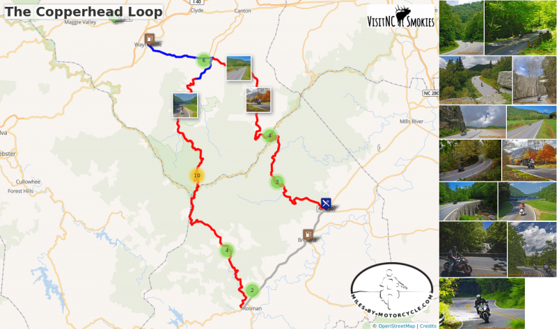
The Copperhead Loop
US 276 and NC 215 are two of the finest motorcycle rides you’ll find.
The Copperhead Loop ride links them using US 64 through Brevard. You'll enjoy wonderfully twisty roads, waterfalls, and intersect the Blue Ridge Parkway at two points.
Distance: 89 MIles
Ride Time: 3 Hours
______________________________________________________________________
Start: Waynesville
- Junction North Main Street and US 276
- Follow US 276 from downtown Waynesville to the traffic light in Bethel.
6.3 Miles
- Turn right at the traffic light onto Love Joy Road
- Follow Love Joy Road to stop sign.
9.1 Miles
- Turn left onto Lake Logan Road and climb to the Blue Ridge Parkway.
24.1 Miles
- Continue south from the Blue Ridge Parkway on Parkway Road to US 64
41.1 Miles
- Turn left onto US 64 and follow it through Brevard to the Junction with US 276 - Pisgah Highway
53.4 Miles
- Turn left on US 276 - Pisgah Highway and follow it to the Blue Ridge Parkway
68.4 Miles
- Continue on US 276 - Cruso Road to the traffic light in Bethel
82.8 Miles
- US 276 - Pigeon Road will lead you back to Waynesville and complete the ride.
END: Waynesville
89.1 Miles
START: Waynesville
Ride: Waynesville to Blue Ridge Parkway (Beech Gap)
-
Start the ride from downtown Waynesville where US 276 leaves from Main Street. A gas station on this corner makes a good meeting point.
-
US 276 - Pigeon Road winds out from town climbing through Pigeon Gap. It then makes a flowing descent to the Bethel Valley. When you reach the traffic light, turn right onto NC 215 - Love Joy Road.
-
NC 215 - Love Joy Road winds along the Pigeon River then out into valley farm land. There's one sharp curve amongst the gentle sweepers that bring you to a stop sign at the junction with NC 215 - Lake Logan Road.
- Turn left to continue on NC 215 - Lake Logan Road to Lake Logan. Above the lake the road starts climbing. The turns get tighter and tighter the higher you climb. You'll pass Sunburst Falls on a hairpin curve, then Bubbling Springs Falls as you get nearer to the top of the climb. Arrive at Beech Gap and the entrance ramp to the Blue Ridge Parkway. A classic break stop is the Courthouse Valley Overlook on the Blue Ridge Parkway to savor the views.
Recommended - Jukebox Junction
Ride: Blue Ridge Parkway - Beech Gap to Wagon Road Gap
-
NC 215 - Parkway Road makes a long drop to meet US Highway 64. It's one of the most techincal sections of the road with challenging curves up high, a short valley run in the middle, then another section of tight and twisty curves near the bottom. There are a couple nice roadside waterfalls near Balsam Grove.
-
Turn left onto US Highway 64. 4 lane sections run east from Rosman through buslting Brevard. Follow through to the intersection with US 276 - Pisgah Highway.
- US 276 - Pisgah Highway leads north along the Davidson River into a very popular area of the Pisgah Forest. It's a pretty ride but expect congestion on nice weekends. Looking Glass Falls is the noteable attraction here, worth a stop for a closer look and a photo. Soon after you'll pass Sliding Rock. The road gently climbs higher and higher through pleasant twists. The higher you get the steeper the grade and the turnns grow progressively sharper. Arrive at the Blue Ridge Parkway junction at Wagon Road Gap at the top of the climb. The Cold Mountain Overlook is a good rest stop.
Ride: Blue Ridge Parkway (Wagon Road Gap) to Waynesville
- The 3 mile drop from the parkway on US 276 - Cruso Road to Big East Fork is exciting. After, the road winds through the woods then emerges into the Cruso Valley. There are a few nice curves along bends in the river. Follow through to Bethel then US 276 - Pigeon Road takes you into Waynesville to complete the ride.
END: Waynesville
The Copperhead Loop
US 276 and NC 215 are two of the finest motorcycle rides you’ll find. The Copperhead Loop ride links them using US 64 through Brevard. You'll enjoy wonderfully twisty roads, waterfalls, and intersect the Blue Ridge Parkway at two points.
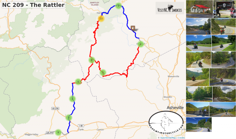
NC 209 - “The Rattler”
Long popular with locals, NC 209 takes you on a wonderful scenic and challenging ride north to Hot Springs.
Extend your ride and make a 100 mile loop by continuing through Hot Springs on US 25, pass through Marshall, then follow Meadows Town Rd to NC 63. NC 63 leads you back to NC 209.
36 miles to Hot Springs. About 1 hour ride.
98 miles to do loop ride. 1/2 day ride.
Route: NC 209 - The Rattler
Junaluska to Hot Springs
Start: Exit 104 on Highway US 74. Lowes store at this exit.
- Pass under US 74. Follow NC 209 north.
3.7 mi
- Cross I-40 at Exit 24. It’s an easy ride through the valleys for a few miles.
11.9 mi
- Turn Right onto Betsy’s Creek Road to continue on NC 209. Ferguson’s store / gas marks this corner. Lots of signs.
22 mi
- Junction NC 63. Note and pass through. - Store and gas at this junction. Popular spot for a break, loop returns here.
36.6 mi
- NC 209 ends at Hot Springs. Return as you came or continue on loop ride.
The Rattler Loop Ride:
- Pass through Hot Springs. Cross the French Broad River and follow US 25 for 5 miles. US 25 will reach a stop sign.
41.7 mi
- Turn right @ stop sign to continue on US 25 / 70 towards Asheville.
50.9 mi
-
Veer right into Marshall on Main Street. Follow into town.
61.6 mi
- Turn right at the traffic light in the center of Marshall and cross the bridge over the French Broad River.
- You are now on Bailey Branch Rd. It will become Meadows Town Road. Meadows Town Road ends in 10 miles at NC 63.
71.5 mi
- Turn Right @ stop sign and follow NC 63 to return to the mid point of NC 209.
85.5 mi
- Turn left @ stop sign onto NC 209 and follow back to Junaluska to finish the ride.
98.4 mi - End of ride
START: Junaulska
Ride: Junaluska to Hot Springs
-
NC 209 - "The Rattler" starts at Exit 104 on US 19 / 74. A Lowes Store is the landmark at this exit. NC 209 - Crabtree Road winds north through the valleys near the Pigeon River, crosses over I-40 at Exit 24 then becomes NC 209 - Rush Fork Road once it leaves the river valleys. Sweeping cruves flow through mountain famland, climb to Rush Fork Gap then drop to the Fines Creek community.
-
NC 209 then shoots east as Betsy's Creek Road rolling into another farm valley for several miles. The landmark at this turn is Ferguson's Supply Store. Just beyond you'll find the "Rattler" sign and a chance to buy t-shirts and swag at the roadside. The road hooks around and climbs Lab Mountain to enter the first section of tight twists through rocky cuts. Cresting Besty's Gap it decends along Spring Creek. The curves relax and you'll pass historic Pink Plemmon's Store as you roll into the tiny settlement of Trust.
-
The Trust General Store is the landmark here. Note the junction with NC 63 - you will return from here to Junaluska to complete the loop ride.
-
NC 209 soon makes a long straight shot across broad Spring Creek Valley then follows the banks of the creek for several more miles of nice curvy road.
-
A sharp hook marks the start of the climb above the creek as you enter the National Forest. Challenging tight curves cut through the rocky bluffs high above the river. As you near Hot Springs a couple nice overlooks offer good stops for photos.
- NC 209 then drops and draws near the river again becoming Lance Avenue as you enter Hot Springs.
Ride: Hot Springs to Marshall
-
Passing through Hot Springs, Lance Avenue becomes US 25 / 70 once you cross the French Broad River. It climbs from the river through sweeping curves then makes a long slow descent to a stop sign at Big Laurel Creek.
- Turn right to continue south on US 25 / 70. The road winds along for several miles to reach the well marked turn onto North Main Street into Marshall. Continue to the stop light in the center of town.
Ride: Mashall to Junaluska
-
Turn at the traffic light in Marshall and cross the French Broad River to reach Baily Branch Road. It winds through hilly terrain south of the river to become Meadows Town Road. You'll reach a stop sign at NC 63 - New Leicester Highway.
-
Turn right and follow NC 63 - New Leicester Highway carving up and over Doggett Mountain then down through the switchbacks to return to NC 209 in Trust.
- Turn left and follow NC 209 back to Junaluska.
END: Junaluska
NC 209 - The Rattler
Long popular with locals, NC 209 takes you on a wonderful scenic and challenging ride north to Hot Springs. Extend your ride and make a 100 mile loop by continuing through Hot Springs on US 25, pass through Marshall, then follow Meadows Town Rd to NC 63. NC 63 leads you back to NC 209.
Tags
Archives
- 7 2018


