


ADV Motorcycle Ride - Hurricane Creek / Wesley Creek Road
Just east of Great Smoky Mountains National Park you'll find one of the most challenging unpaved motorcycle rides in the area.
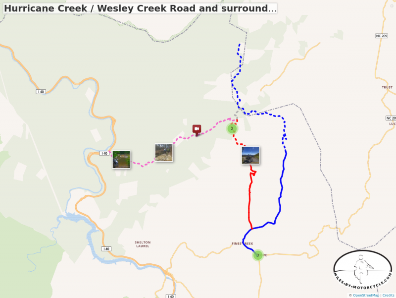
Hurricane Creek / Wesley Creek Road and surroundings
The ride on Hurricane Creek Road / Wesley Creek Road is one of the most challenging unpaved rides in the area.
There are plenty of good national forest roads in the area near the North Carolina / Tennesse border. The bulk of them are well maintained gravel roads. Hurricane Creek Road is an exception.
Unable to embed shared object. Sharing permissions error?
The west end of this route connects to Interstate 40 in the scenic Pigeon River Gorge. It can only be reached from the northbound lane heading into Tennessee. The tiny road disappears into the forest just beyond the large "Harmon Den - 1 Mile" highway sign.
The east end of the route connects to Max Patch Road north of the Fines Creek Community. Here it starts as paved Wesley Creek Road marked with a "No Outlet" sign. The narrow paved section of Wesley Creek Road climbs through some very steep switchbacks. The pavement ends as it approaches Bear Wallow Gap then sneaks into the woods.
True to it's name Hurricane Creek Road skates along the edges of the creek as it gradually climbs from west to east. Not long into the ride you face the big water crossing, an intimidating pool, the first of many more crossings though none so large. The ride is rocky, wet, full of holes and ruts. Eventually the creek fades and Hurricane Creek Road meets Wesley Creek Road. A spur shoots north to Max Patch Road and you can escape the ride here if you've had enough.
Continuing from the junction, Wesley Creek Road soon turns into the roughest, steepest, and rockiest portion of the ride. The pavement begins once you reach the crest and drop through a few good curves.
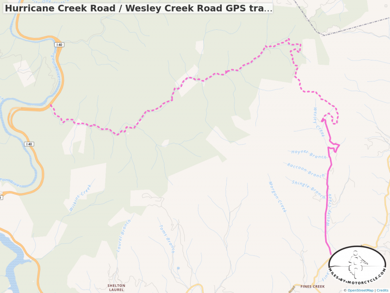
Hurricane Creek Road / Wesley Creek Road GPS track
Starts at I-40, west end. Single track linking the two roads for download as a .GPX file.
This mapped route is done west to east making the climb. The large water crossing is a little easier this way, the steep rocky spots at the top a little more difficult. Riding it the other direction, east to west, the downhill may make the steep parts easier and the water challenge a little tougher. Either way Hurricane Creek Road is quite a ride for those who like a challenge.
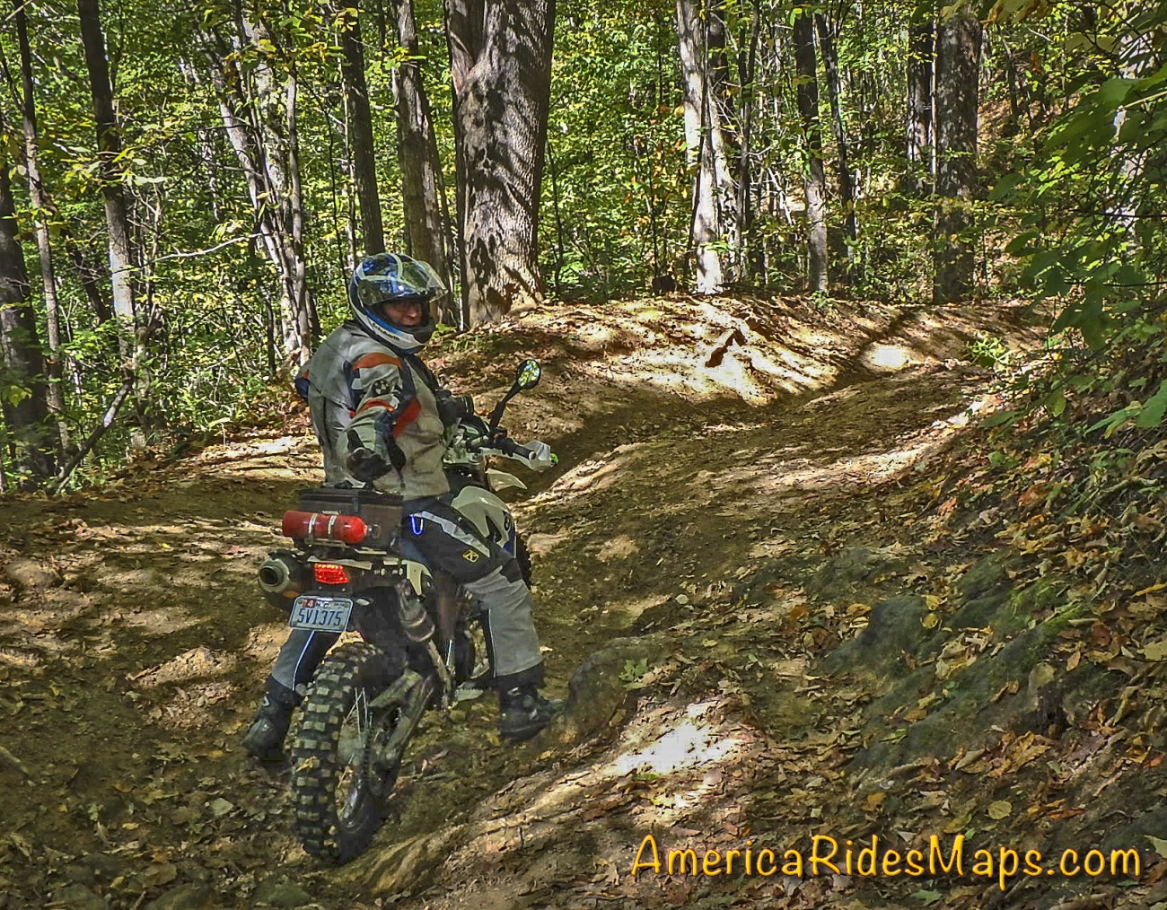
Hurricane / Wesley Creek Rds Group Dec 2 17
A group ride on Hurricane Creek Road to Wesley Creek Road with a talented bunch of adventure riders. Wet, rocky, steep near the end.
These Unpaved Roads and many other Great Rides are found on Map OR1 - The Best Unpaved Roads EAST of Smoky Park
You'll find the wealth of fabulous Paved Roads in this area on maps -
Map #6 - The Best Motorcycle Rides Near Smoky Mountains Park - EAST
Map - 100 Great Motorcycle Rides in the Smoky Mountains
Waterproof, durable, easy to read, Motorcycle Ride Maps done right!
America Rides Maps
Maps of Great Motorcycle Rides in the Blue Ridge Mountains. Blue Ridge Parkway, Tail of the Dragon, hundreds of great biker roads for motorcycle touring. Tennessee, North and South Carolina, Virginia, Georgia motorcycle ride maps,
http://AmericaRidesMaps.com
America Rides Maps makes the most detailed and comprehensive maps of the Blue Ridge Mountains. A series of easy-to-use pocket maps cover the mountains from Virginia to Georgia showing all the best roads and good roads to link them together.
100 Great Motorcycle Rides in the Smoky Mountains | America Rides Maps
100+ Great roads surrounding the Smoky Mountains
https://americaridesmaps.com/produc...
Southeast Blue Ridge Map Package | America Rides Maps
Full Southeast Package, motorcycle maps, motorcycle touring, touring the blue ridge, ride the Blue Ridge Parkway, best motorcycle rides
https://americaridesmaps.com/produc...
Motorcycle Rides surrounding Great Smoky Mountains National Park | America Rides Maps
Motorcycle Rides surrounding Great Smoky Mountains National Park maps, motorcycle smoky mountains, great rides near Great Smoky Mountains, Best motorcycle rides
https://americaridesmaps.com/produc...
3 Map Smoky Park Unpaved Set | America Rides Maps
The unpaved roads in and surrounding Great Smoky Mountains National Park
https://americaridesmaps.com/produc...
#6 The Best Motorcycle Rides Near Smoky Mountains Park - EAST | America Rides Maps
East and south of the Smoky Mountains, the land of the Waterfalls.
https://americaridesmaps.com/produc...
#7 The Best Motorcycle Rides Near Smoky Park - SOUTH | America Rides Maps
South and west of the Smoky Mountains, Waterfalls, The Dragon, and some of the best riding.
https://americaridesmaps.com/produc...
Best Rides NORTH of Smoky Park | America Rides Maps
Rides on the North side of the Smoky Mountains around Gatlinburg, Pigeon Forge, an the surroundings.
https://americaridesmaps.com/produc...
Tags
- 5 americaridesmaps
- 4 north_carolina
- 4 map100smokies
- 3 map6
- 3 scenic
- 3 Map12ClassicRides
- 2 vlogging
- 2 overlook
- 2 historic
- 2 tennessee
- 2 video
- 2 attraction
- 2 MapOR2
- 1 Virginia
- 1 classic
- 1 GoPro
- 1 named
- 1 map2
- 1 MapOR1
- 1 map7
- 1 map8
- 1 mapor1
- 1 Roanoke
- 1 Map100SouthernRides
- 1 Connects_To_Parkway
- 1 Blue_Ridge_Parkway
- 1 view
- 1 map9
- 1 Georgia
- 1 books
- 1 west_virginia
- 1 swag
- 1 store
- 1 Good_Rest_stop
- 1 TN
- 1 coveredbridge
- 1 gopro
- 1 mapOR3
You must be a member of this group to post comments.
Please see the top of the page to join.