


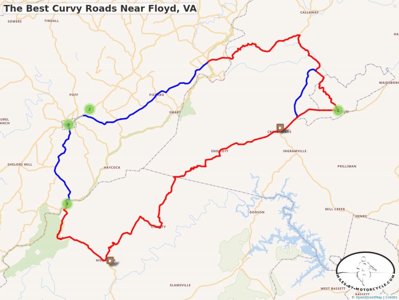
The Best Curvy Roads Near Floyd, VA
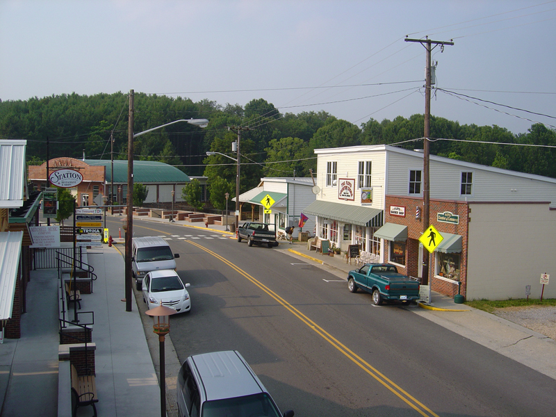
Floyd, Virginia sits just 6 miles from the Blue Ridge Parkway not far from the border with North Carolina. It's a favorite place to stay as it's such a fun town with good food, nice shops, lots of live music and great roads to ride all around. This is a nice loop ride from town that takes you on some fun roads.
The Best Curvy Roads Near Floyd, VA
This 59 mile loop south of Floyd, VA takes you on a nice romp through some of the best twisty sections of the road near town. It crosses the Blue Ridge Parkway twice, and runs through the campus of historic Ferrum College. Sawmill road can be used to bypass the school.
START: Floyd
RIDE: Floyd to Ferrum
- Take VA 8 south from town towards the Blue Ridge Parkway. It's an easy ride, nice and curvy, that soon leaves town behind rolling out into the woods and farms. You'll reach the parkway at Tuggles Gap.
- Pass under the Parkway and continue on VA 8. Tuggle's Gap Restaurant and Motel are just off the parkway exit. Beyond, VA 8 makes a twisty plunge through a series of nice switchbacks before it relaxes again on the way to Woolwine.
- Turn onto VA 40 - Charity Highway to start the ride east. You'll soon hit the first twisty section. It's a mostly wooded run, surrounded by hills with a few homes here and there. The road remains full of curves for several enjoyable miles. It doesn't relax until you get near Ferrum.
- The valley opens up as you near Ferrum. You can use Sawmill Road to bypass Ferrum College, though it's a nice ride through the historic campus and there are some curves just over the hill you'll miss. When you reach the college turn onto Ferrum Mountain Road.
RIDE: Ferrum to Floyd
- Pass through the campus on Ferrum Mountain Road then wind down the back side of the mountain. It's wooded, tight and twisty until you reach some broad open feilds. When you pass them and reenter the woods, watch for the turn onto 5 Mile Mountain Road.
- 5 Mile Mountain Road is a tiny paved road which rolls through homes and open fields for a bit then gets twisty as it climbs up onto the mountain. There are several unpaved pull-offs along the road where you can get views back down the valley. You'll emerge from the trees into some small farms and arrive at a stop sign at the Blue Ridge Parkway.
- Cross the Blue Ridge Parkway onto Franklin Pike SE. It meanders through wooded spots and farms as it makes it's way back towards Floyd. You'll arrive at US 221.
- A short section of US 221 brings you back to the heart of town.
END: Floyd
These and many other Great Roads are found on maps -
Map #2 - The Roads Of Roanoke and Beyond
Map #3 - North Carolina / Virginia Border Rides
America Rides Maps
Maps of Great Motorcycle Rides in the Blue Ridge Mountains. Blue Ridge Parkway, Tail of the Dragon, hundreds of great biker roads for motorcycle touring. Tennessee, North and South Carolina, Virginia, Georgia motorcycle ride maps,
http://AmericaRidesMaps.com
America Rides Maps makes the most detailed and comprehensive maps of the Blue Ridge Mountains. A series of easy-to-use pocket maps cover the mountains from Virginia to Georgia showing all the best roads and good roads to link them together.
100 Great Motorcycle Rides in the Smoky Mountains | America Rides Maps
100+ Great roads surrounding the Smoky Mountains
https://americaridesmaps.com/produc...
Southeast Blue Ridge Map Package | America Rides Maps
Full Southeast Package, motorcycle maps, motorcycle touring, touring the blue ridge, ride the Blue Ridge Parkway, best motorcycle rides
https://americaridesmaps.com/produc...
Motorcycle Rides surrounding Great Smoky Mountains National Park | America Rides Maps
Motorcycle Rides surrounding Great Smoky Mountains National Park maps, motorcycle smoky mountains, great rides near Great Smoky Mountains, Best motorcycle rides
https://americaridesmaps.com/produc...
3 Map Smoky Park Unpaved Set | America Rides Maps
The unpaved roads in and surrounding Great Smoky Mountains National Park
https://americaridesmaps.com/produc...
#6 The Best Motorcycle Rides Near Smoky Mountains Park - EAST | America Rides Maps
East and south of the Smoky Mountains, the land of the Waterfalls.
https://americaridesmaps.com/produc...
#7 The Best Motorcycle Rides Near Smoky Park - SOUTH | America Rides Maps
South and west of the Smoky Mountains, Waterfalls, The Dragon, and some of the best riding.
https://americaridesmaps.com/produc...
Best Rides NORTH of Smoky Park | America Rides Maps
Rides on the North side of the Smoky Mountains around Gatlinburg, Pigeon Forge, an the surroundings.
https://americaridesmaps.com/produc...
Tags
- 5 americaridesmaps
- 4 north_carolina
- 4 map100smokies
- 3 map6
- 3 scenic
- 3 Map12ClassicRides
- 2 vlogging
- 2 overlook
- 2 historic
- 2 tennessee
- 2 video
- 2 attraction
- 2 MapOR2
- 1 Virginia
- 1 classic
- 1 GoPro
- 1 named
- 1 map2
- 1 MapOR1
- 1 map7
- 1 map8
- 1 mapor1
- 1 Roanoke
- 1 Map100SouthernRides
- 1 Connects_To_Parkway
- 1 Blue_Ridge_Parkway
- 1 view
- 1 map9
- 1 Georgia
- 1 books
- 1 west_virginia
- 1 swag
- 1 store
- 1 Good_Rest_stop
- 1 TN
- 1 coveredbridge
- 1 gopro
- 1 mapOR3
You must be a member of this group to post comments.
Please see the top of the page to join.