Miles By Motorcycle
established 11 years ago
Travel ResourcesSubscribe to this blog RSS Feed
    You must be logged in and belong to this group to post to this forum.
    1 of 28
    Yermo
    10 years ago
    What online travel resources. for research, planning, or ideas do you use? 

    I came across this site today:

    Link #9011
    Yermo
    10 years ago

    Wikitravel - The Free Travel Guide

    Open source travel guide featuring up-to-date information on attractions hotels restaurants travel tips and more. Free and reliable advice written by Wikitravellers from around the globe.

    http://wikitravel.org/en/Main_Page
     
    2 of 28
    DaFish
    10 years ago
    Yermo, the wife and I usually pick a destination and migrate towards it. We like the two lane back roads as the interstate system is a great way to save time and see NOTHING!

    I do check out a few sites to see what roads are in the areas we are traveling like this one;


    Link #9078
    Yermo
    10 years ago

    9959 Motorcycle Rides and Motorcycle Roads

    The Best Motorcycling Roads logged by 23729 motorcycle travellers for bike riding

    http://www.bestbikingroads.com
      

    Sometimes though, there is a freshly paved road going in the general direction we are headed. This would be a required detour IMHO!

    We have a few other sites that we use also but one of the best is; contact the states that you will be traveling through.

    Last year for example, we found ourselves traveling through Mississippi. There are Blues markers in the state near where some of the blues greats have called home. The welcome center on I-59 did a good job of giving us a map which included ALL of the locations for these markers. This is a trip we are planning this year. (Yeah, the Blues and biking go together "Like peas and carrots". 10 extra points for anyone that can tell me what movie that is from!
    3 of 28
    Lisa Epifano Hall
    10 years ago
    I've used   for years. I plan and map out all of the trips we take and find this website useful. I also use google earth to see exactly what I'm getting myself into. I like to be prepared
    4 of 28
    Yermo
    10 years ago
    Lisa Epifano Hall Thanks!

    Do you take a GPS along on your rides? (I forget if I've asked that question before)
    5 of 28
    Lisa Epifano Hall
    10 years ago
    I don't like to go anywhere without my GPS. But I tell it where I want to go! I put all custom routes in, never letting it decide the route.
    6 of 28
    Yermo
    10 years ago
    What kind is it?

    Do you know how to pull GPX tracks off of it? If so, you can upload your rides with a description here (in the Maps section) or you can send me the file and I can do it for you. The when other people plan rides through that area they'll be able to use your ride, and the rides of so many others, to use as a reference. 

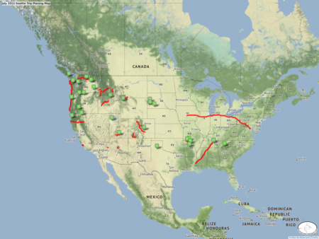
    Eventually, I'm going to build in the ability to pick and choose parts of others trips to include on your own trip maps, sort of like what I did long hand for my cross country trip this last summer:
    Map #6956
    Yermo
    11 years ago

    July 2013 Seattle Trip Planing Map

    A little bit of route and sight planning for the upcoming 2013 Seattle Trip.


    eventually these maps will be downloadable to the GPS.
    7 of 28
    Lisa Epifano Hall
    10 years ago
    It's a Zumo 660. I've been meaning to set some time aside and load some of my favorite routes in the map section here. I'm currently planning our trip Sapphire NC in May, doing my research by finding all the great roads I haven't taken yet. We go to NC at least once a year taking the BRP all the way down. 
    8 of 28
    Yermo
    10 years ago
    Now you're speaking my language. The start of the BRP is about 180 miles from here. I /love/ that road and have done the length of it many times. 

    And I find myself in the Smokey Mountains anywhere from 1 to 4 times a year. I love riding down there. 

    If you try the maps and it fails on you please let me know. There are a number of bugs I have to fix, but it sort of works if you're gentle with it. (Otherwise you can send me any routes you'd like included and I'll put them up for you.)
    9 of 28
    Lisa Epifano Hall
    10 years ago
    My dream is to live minutes from the parkway and ride it anytime I'd like. It is my favorite road so far.  It's about 300 miles from me.  I make sure I go at least once a year. As soon as I get on it I feel like this is where I belong. 
    10 of 28
    Yermo
    10 years ago
    I know the feeling! 

    There are /so so very many/ wonderful roads off the BlueRidge and all around from top to bottom. One could spend years exploring them all.
    11 of 28
    Lisa Epifano Hall
    10 years ago
    Speaking of roads off the BRP have you ever tried Route 151 near Waynesville, NC. I've found that to be the most technical road I've been on to date.  It's really steep with switchback after switchback. Lots of fun!  Although the first time I was on it was just after a rain and wet leaves were all around making it a lot more interesting. 
    12 of 28
    Yermo
    10 years ago
    I've been on 276 as I've stopped in Waynesville a few times. I think I remember this road.

    Yermo
    10 years ago
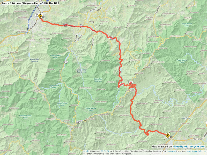
    Notable Road (9121)
    Route 276 near Waynesville, NC Off the BRP

    Route 276 near Waynesville, NC Off the BRP

    A wicked twisty little steep road off the Blue Ridge Parkway in North Carolina.

    (Download Screenshot)

    But I'm not familiar with 151. 

    I'm a lover of super technical roads. 
    13 of 28
    Lisa Epifano Hall
    10 years ago
    I'm very familiar with 276. We usually stay on Maggie Valley and that's the road off BRP that we take. You'll have to try 151 and let me know what you think
    14 of 28
    DaFish
    10 years ago
    151 in North Carolina Huh? I like where ya'll are going! keep it up!

    I have one for you to try also.
    Hwy 123 in Arkansas North of Hwy 7
    15 of 28
    Lisa Epifano Hall
    10 years ago
    Take a look. It's not a long road but the part by the BRP is phenomenal
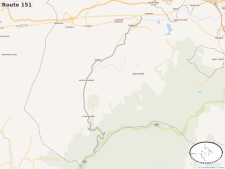
    Map #9127
    Lisa Epifano Hall
    10 years ago

    Route 151

    Steep curves and switchbacks. Not very long but worth it

    16 of 28
    Yermo
    10 years ago
    Lisa Epifano Hall ok, now i found it. Yea, that does look like fun but short. I'm adding it to my todo list as I can't remember if I've ridden it or not.

    Yermo
    10 years ago
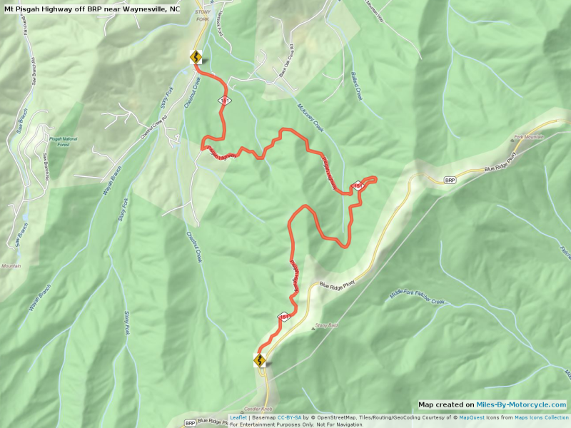
    Notable Road (9129)
    Mt Pisgah Highway off BRP near Waynesville, NC

    Mt Pisgah Highway off BRP near Waynesville, NC

    Super technical steep short little road off the BRP.

    (Download Screenshot)

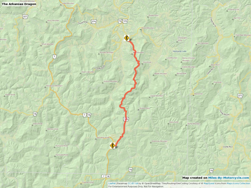
    DaFish Isn't the Arkansas Dragon?

    Yermo
    11 years ago
    Notable Road (6961)
    The Arkansas Dragon

    The Arkansas Dragon

    A road recommended via Road Runner I believe.

    (Download Screenshot)

    I rode this last summer. Crazy switchbacks on the far side.
    17 of 28
    Yermo
    10 years ago
    Lisa Epifano Hall That map worked for you! Excellent!
    18 of 28
    Lisa Epifano Hall
    10 years ago
    Piece of cake
    19 of 28
    Lisa Epifano Hall
    10 years ago
    I just wish I could stop hitting the reply button too fast and leaving an empty reply.
    20 of 28
    DaFish
    10 years ago
    Yes it is the Arkansas Dragon. I rode it this past year for the first time.

    Now that road near Pisgah National Forest? I rode one there to the BRP last year also but I don't think it is the same one.
    21 of 28
    Yermo
    10 years ago
     Lisa Epifano Hall Hmm. Good point. I'll add a check to prevent empty posts.
    22 of 28
    Yermo
    10 years ago
    DaFish There are so many good roads. I've gotten into the habit of taking a GPS with me just to track what roads I've ridden and which I haven't.

    Oh, and by the way, for each map that gets saved there's a full res screenshot generated (which is why it's so slow to save) but you are totally allowed to do whatever you want with the screenshots except remove the attribution at the bottom right. 

    So you can put together a map and then share the screenshot of it out to Facebook or where ever, or print them out, publish them in a book, do whatever you want.

    (which is why I'm not using Google Maps for this stuff).

    Just click Download Screenshot)
    23 of 28
    Yermo
    10 years ago
     Lisa Epifano Hall I just now realized where your profile picture was taken. Duh. 
    24 of 28
    Lisa Epifano Hall
    10 years ago
    The dragon has been an annual trip since 97.  My first time on it a tractor trailer was coming at me from the opposite direction. The cab was in the correct lane but the trailer was on my side. Gotta love when that happens. 
    25 of 28
    DaFish
    10 years ago
    Hey ya'll. You don't have to be so formal! "Fish" is fine!

    As for the screen shots/save. Uggh...I still use 2 dimensional maps folks! That's why I take unscheduled detours sometimes