We now have what is slowly becoming the humble beginnings of a social mapping system. Maps are created from the /maps page (see the top bar).
Uploading GPS tracks works like a champ. You can also click on the maps to place waypoint markers and then click calculate route to calculate a route between them.
IMPORTANT: When uploading GPS tracks please make sure to review the map for any waypoints that might be in the file you uploaded. For instance, on my Garmin it always adds my "Home" waypoint with my address so before saving the map I always delete that way point. (Just right click and select delete)
You can right click and start a new route. This way you can plan out different sections on a single map.
I'm using a mapping API called Leaflet and it has some hardcore bugs. If you click and you notice the markers are showing up some place else scroll the map slightly. It somehow gets out of sync and I haven't yet tracked down exactly what's going on. As is the case with so much of this browser happiness, it's a case of trial and error.
Also, sometimes the markers aren't showing up right which again seems to be related to the same bug. Scroll the interactive map a bit and the markers show up.
You'll notice that sometimes markers group together into little circles. As you zoom out instead of becoming a cluttered mess of markers they neatly arrange themselves into groups under circles. Clicking on the circles expands out the markers that are contained in that circle. (click on the interactive map at the bottom of this post and you'll see what I mean.) This is called the markerCluster feature. It's rather nice if you have a map with bunches of tagged roads and lots of markers.
Once you can a line drawn on the map, you can click on it to tag sections of it. For instance, you can click the start point on a route and then the endpoint and describe it as "twisty" or "scenic". It then gets added to the index of tagged roads.
You can right click to enter and zoom the map.
You can use the little red pin to look up places by street address or place name and state.
You can also click on a section of a track or route and delete it.
Please note that I'm generating screenshots of the maps and tagged roads. This means it is /SLOW/.
So when clicking SAVE please wait 60 seconds. it can take quite a while for the screenshots to generate and there's currently no feedback. (Yea, sorry. I know. I'll fix it.)
I have the little "please wait" dialog mostly built but couldn't get it finished this evening. I will eventually figure out a way to make the rendering of screenshots faster. As it is, it's this screenshot facility that has taken so much time to get working. (From a technical point of view it has been quite challenging for a number of annoying reasons.)
I hope to write up some user documentation after I get back from my Blue Ridge trip.
So here's a map:
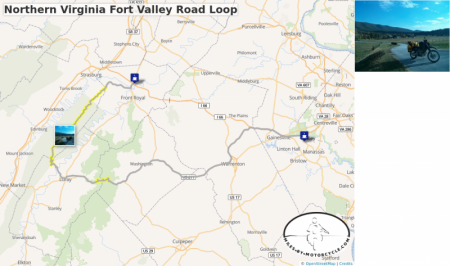
Northern Virginia Fort Valley Road Loop
This is one of our favorite routes through Northern Virginia. We typically start out at 55 where it meets 15 and take side roads down to 17 until it connects to 211.
There's a wonderful section of tight technical but well graded switchbacks on 211 as you approach and cross Skyline Drive.
We usually have lunch in Luray and from there head up to Route 675 which is a series of switchbacks the carves it's way up the side of the mountain. There are wonderful vistas as you go up. Very pretty.
From there you catch Fort Valley Road which goes on seemingly forever as it winds it's way through this magical looking valley of pristine farms and old buildings. It eventually narrows to a tight state park road that follows a roaring creek bordered by steep canyon walls in a deep wood.
We typically make our way to the Starbucks in Front Royal before taking the Superslab back home. Sometimes we'll take 55 for some local color as it winds it's way seemingly through towns that time forgot.
The best sections are tagged in yellow.


