Miles By Motorcycle
established 11 years ago
What I'm working onSubscribe to this blog RSS Feed
    You must be logged in and belong to this group to post to this forum.
    1 of 5
    Yermo
    11 years ago
    Here's a quick very rough list of what I'm working on and in what order, in addition to what I'm planing for the next few months of my life, for the curious. For the time being, I am primarily focused on the development of the maps support. 

    As you've seen with the screen shots, it's coming along rather nicely. I've made quite a bit of progress on adding support for importing data from GPSs and GPS apps. (For those that do not have a dedicated GPS I suggest taking a look at Open GPS Tracker. It can also generate the same kind of GPS tracks the Garmin units can. It might be something for rshaug to look at.)

    So this is where I'm at:

    Upload GPS waypoints from GPX and display on interactive map, done
    Upload GPS routes from GPX and display on interactive map, done.
    Upload GPS tracks from GPX and display on interactive map, done.

    Using the mouse, put user route waypoints on the map, done.

    Being able to selectively show/hide any of the above, so you can have the calculated route from the GPS next to the actual track you followed, next to way points and turn any of them on and off. Done.

    ---------------------------------------------
    Stuff I want to get done before maps go live:
    ---------------------------------------------

    Calculate a route between points from above. This will let you plan out of a ride and then connect the dots with a calculated route. In progress now.

    Add a "point of interest" on the map using right click and select a type icon (good road, lodging, food, good view, etc), next.

    Reverse geocoding of POI points (turn lat/lng to address) to save address along with POI, after that.

    Save all of the above in addition to title/description/tags out to database. 

    Generate a static image of the map and all the routes/points added. (hard)

    Create list of maps and POI's page (similar to links page) using the static images from above. Click through the image to get the interactive map.

    Add basic searching of waypoints and POI's.

    Add downloading of GPX version of map.

    Add an Add Map tab to the forum INSERT menu.

    Release. ETA, this month.

    Then I do some rounds of bug fixing, field the new server and generally improve what we have.

    -----------------------------------------------
    Things I am planning after release of the maps, not necessarily in order:
    -----------------------------------------------


    Adding photos to the map with thumbnails viewable on the map.

    An address/latlong search feature to make finding a given point easier than having to pan around to find it.

    Crossposting to Facebook/twitter/etc.

    Geo searching.


    Add a Maps tab to the user profiles (actually I need to completely rework on the user profiles).

    -----------------
    Ride planner:
    -----------------
    Ride planner which allows you to take a map and turn it into a ride event. Once in ride planning mode you'll be able to add ride event items to the map which will be a combination of meeting points and other items such as :

    Invite members - invite members to join the ride. Keep track of the accept/decline/maybe status.

    Invite watchers - invite non-riders to lurk on the ride.

    add a meeting point - we meet at startbucks at 10AM

    add lodging point - we have reservations at Deal's Gap with room for 6. These points would allow people to reserve space and it would keep track of who is going and not allow more than the max people to sign up.

    events - for instance we may have a ride that involves a larger event that others who are not on the ride might want to join such as go-cart racing. Will have the same ability to set number of people limits. e.g. 10 people on the boat.

    A "guest/suggestion" mode that allows members viewing a map to place a suggestion on the map of a place to go/thing to see and make those suggestions searchable as a separate object type.

    ---------------------------------------------
    Mobile App for Android, Iphone, Windows Phone
    ---------------------------------------------

    Mobile Status Updates/Taggging - (later this summer)

    Be able to participate in a scheduled ride.

    Optionally broadcast/record location for the other riders.

    Mark places on a map where we are intending to head with an ETA so other riders can decide whether or not to join us. 

    geo-tagged status update as we go on the ride so we can remember cool things we've seen along the way.

    Upload photos to the map as the trip progresses.

    Indicate intention to meet up at a given meeting point. Broadcasts to all members on the ride.

    Be able to show all events that were recorded on a ride on the map as another layer (so we can see what was planned and then what actually happened).

    Add searching of ride events so the map in addition to the ride events become a searchable thing.

    Much more ....
    2 of 5
    Yermo
    11 years ago
    I forgot to mention the calendar view of ride events.
    3 of 5
    Yermo
    11 years ago
    I have the first version of the route planner built using the liberally licensed router service by CloudMade:
    Link #5719
    Yermo
    11 years ago

    CloudMade - The Location Platform Serving OEMs, Enterprises & Developers

    CloudMade provides you with access to a range of innovative tools and APIs that allow you to make the most of all map data

    http://cloudmade.com

    Unfortunately, Google has set the bar incredibly high with their maps and routing. While the CloudMade router works, it often gives unpredictable or partial results. It's also very sensitive to subtle positioning of waypoints.

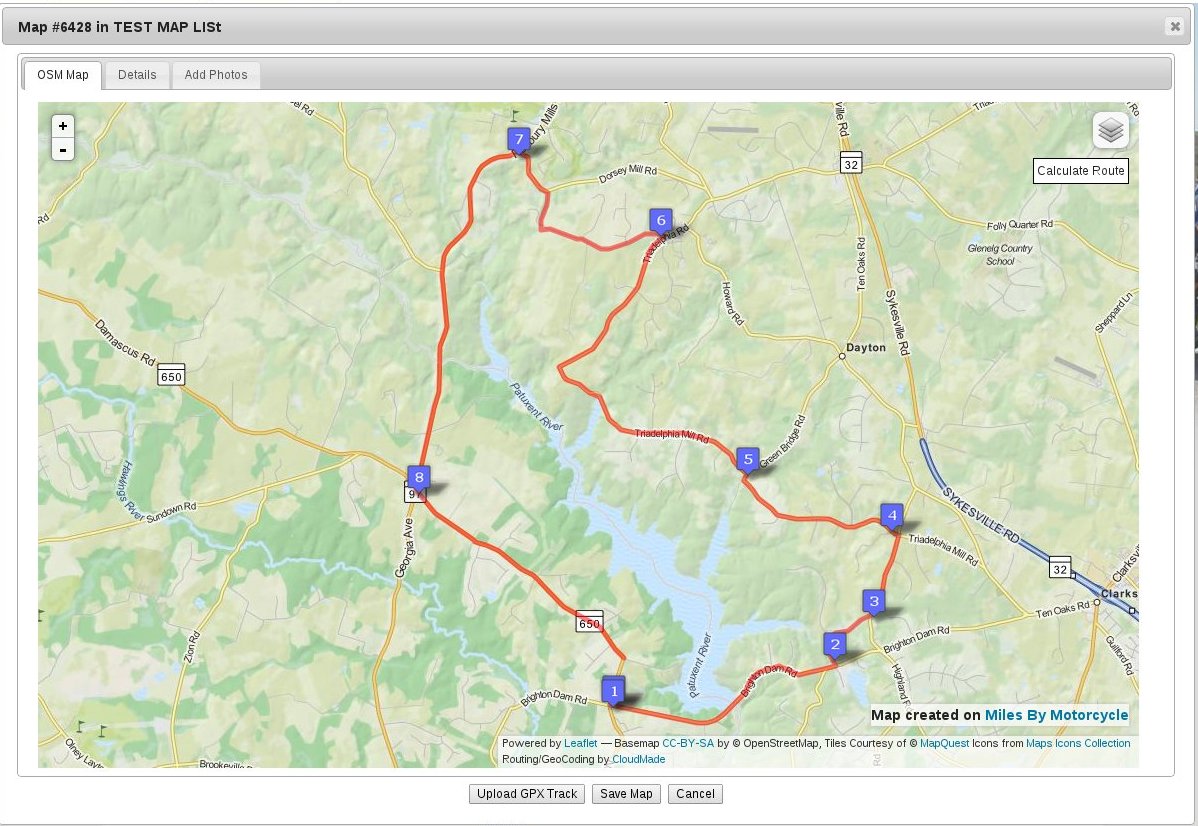
    The way I have it implemented at the moment is you click on a series of points on the map. Each time you click a numbered marker is dropped. Once you have your markers set the way you want you click "Calculate Route" which makes a request out to CloudMade's routing service. Conveniently, it returns a route in the same GPX format that the GPS units use, so I didn't have to write much additional code to parse the result. Once I retrieve the result from CloudMade I send it to the browser where I then render the result on the map. 

    CloudMades router is still a late alpha/early beta level offering so I suspect that as time goes on it will improve, assuming they stay in business. From their about page it sounds like they are pretty serious. Given how draconian Google is with their data, basing a business on more open data is likely to attract a lot of developers. 

    The upshot is, once I release the maps to the site, laying out routes on the site will be a bit annoying. I find that you end up putting in two or three waypoints, click route and then if the result isn't what you expect you have to futz with the way points moving them around a bit until the router picks them up correctly. It's a trial and error effort. 

    I'd love to use MapQuests router or one of the other big service providers, but every one I have looked at prevents you from using any of their calculated data with any other service, so for instance, I can't use Bing routes on an OpenStreetMap map and I certainly wouldn't be allowed to export them. 

    But, with some trail an error one can get a route put together. As I mentioned, I suspect CloudMade will improve their service over time. I have sent them an email.

    So here's a first route layed out in my development code:

    Photo #5720
    Yermo
    11 years ago
    Power of Left

    Power of Left

    A route found by Matt back in the day when he asked himself a question: "How far can I go by only turning left?" The answer is about 22 miles.
    This was a route found by Matt way back in the day up in the Olney, Md area. He asked himself "I wonder how far I can go only turning left?" The answer is about 22 miles. I took Torch on this ride last year. It's a really nice route. 
    4 of 5
    Yermo
    11 years ago
    So I've run into a problem. Not only is CloudMade's router somewhat less than stellar their geocoder (the thing that turns addresses into lat/lngs and lat/lngs into addresses) is just too poor to use, even for our humble site. Geocoding is a critical feature because it allows us to figure out if two lat/lngs are the same place. (Otherwise we might have umpteen different entries it the database for Deal's Gap and we'll have a "will the real Deal's Gap please stand up" situation, which nobody wants. When you go to Deal's Gap there should only be one Deal's Gap entry regardless of where in the parking lot you happen to be standing.)

    So I have spent the day exploring options all over the net. Frustrated by countless services that simply didn't work, I started exploring relatively expensive offerings but even those didn't allow me to do everything I want.

    Towards the end of the day, however, I came across the complete set of documentation of the MapStreet Open APIs. 


    Link #5730
    Yermo
    11 years ago

    Open Data Map APIs and Web Services - MapQuest Developer Network

    An overview of MapQuest's Open APIs and SDKs which rely heavily on OpenStreetMap, a crowd-sourced mapping project where the underlying map data is free and editable by the whole world.

    http://developer.mapquest.com/web/p...
     
    Doing some initial tests it seems this offering is MUCH more complete and solid and compares relatively well against Google. They even support dragging routes around just like google.

    So the upshot is, I've decided that CloudMade is simply not going to cut it. I'm going to fallback and re-implement what I've built using the MapQuest Open API's. This means maps won't be on the site this week, Maybe next week or the week after.

    But the resulting functionality will:

    1. be much better than I was fearing.

    2. will allow us to save/store/query/manipulate the data any way we want

    3. should provide a MUCH better experience.

    My big fear is that this open API of theirs, since it's free and completely open to the world, might just go away which would leave us without maps. Hopefully they keep the service going or maybe come up with a premium service on separate servers to allay the fear that they will discontinue the service.
    5 of 5
    Yermo
    11 years ago
    I have the Map Quest Open free "directions" API implemented for routing and it is /significantly/ better than the CloudMade service. Since it's based on OpenStreetMap data there are still glitches but in relatively populated areas it seems to work very well. It's also quite fast.

    Of course, it doesn't want to route one of our favorite rides, Virginia Route 675 to Fort Valley Road. In those cases we can always just upload a GPS track.

    Slowly it's coming along.