
Visit NC Smokies - Motorcycle Rides - Public
established 6 years ago


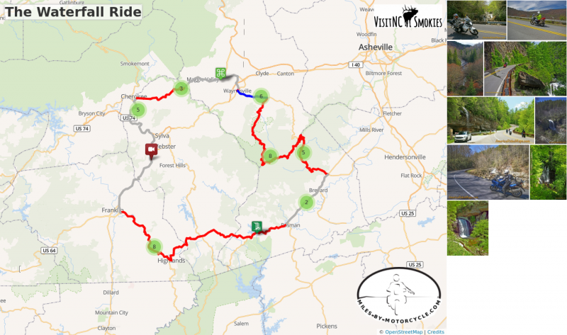
The Waterfall Ride
Tour almost a dozen roadside waterfalls on this scenic day ride.
Distance: 165 miles
Ride Time: All day ride
Difficulty: Easy to moderate difficulty
Start: Maggie Valley
- Starting at the Haywood Visitor Center, follow US 19 - Soco Road west.
7.3 Miles
- Pass under Blue Ridge Parkway at Soco Gap and continue on US 19 - Wolftown Road
8.9 Miles - Soco Falls
- Gravel pull off on left with small signs on the downhill section of US 19 on a sharp curve. The falls can’t be seen from road. A path and boardwalk lead to an overlook with 2 converging waterfalls.
18 Miles
- Continue on US 19 into Cherokee. Turn left @ traffic light onto Casino Road to cut to US 441 south.
18.8 Miles
- Turn left @ traffic light onto US 441 south to leave Cherokee and merge onto US 74 east (Exit 74).
21.6 Miles
- Follow US 19 / 74 / 441 (Great Smoky Mountains Expressway) east to Dillsboro.
29.5 Miles
- Leave the highway at Exit 81, pass Dillsboro and continue south. Follow US 441 south to Franklin.
47.3 Miles
- Exit US 441 and follow NC 28 / US 64 east. NC 28 leads into the Cullasja Gorge.
52.6 Miles - Cullasaja Falls
- Visible from road on right. Limited and hazardous parking near guardrail on sharp curve.
57.4 Miles - Quarry Falls
- Visible from road on right. Long paved pulloff on right side of road.
60.7 Miles - Dry Falls
- Not visible from road. Paved parking on right with signs. Short trail to waterfall. Path continues behind waterfall.
61.4 Miles - Bridal Veil Falls
- Visible from road on left. Paved pull off. Drive behind the waterfall for a photo.
64.2 Miles
- Turn left @ traffic light in Highlands to continue on US 64.
86.7 Miles - Toxaway Falls
- Not visible from road. Road crosses dam with waterfall below. Difficult to get a good view. Park at Toxaway Village or along road on dam.
- Continue on US 64 east past Rosman and through Brevard
106.2 Miles
- Turn left @ traffic light onto US 276 north. Ride north into the Pisgah Forest.
111.9 Miles - Looking Glass Falls
- Visible from road. Large paved parking along road on right. Boardwalk to base of falls.
114 Miles - Sliding Rock
- Not visible from road. Fee area $2. Paved parking lot. Bathers slide down waterfall. Continue climbing on US 276 to the Blue Ridge Parkway.
121.2 Miles
- Turn right onto parkway ramp. Turn left at the stop sign to head south (towards Cherokee) on the Blue Ridge Parkway.
128.2 mi - Second Falls
- Graveyard Fields - Not visible from road. 1/3 mile paved walk to top of Second Falls. Trails continue to 2 others.
132.9 Miles
- Exit Parkway. Turn left (towards Canton) on NC 215. Descend from the parkway on NC 215.
134.8 Miles - Bubbling Spring Falls
- Visible from road. Hard to find. Look for 3rd gravel pull out on right on the only straight section of road.
137.2 Miles - Sunburst Falls
- Visible from road on left. River plunges beneath the roadway on a hairpin curve. Small unpaved parking are just beyond. Follow NC 215 - Lake Logan Road to US 276.
150.2 Miles
- Turn left @ stop sign to follow US 276 into Waynesville.
155.8 mi
- Turn right @ traffic light in Waynesvile. Pass through town on Main Street.
156.25 Miles
- turn left onto US 276 - Russ Avenue. Follow to US 19.
158.7 Miles
- Turn left onto US 19 - Dellwood Road. Follow to Visitor Center
162.09 Miles
END: Maggie Valley
Start: Maggie Valley
Ride: Maggie Valley to Franklin
-
Follow US 19 - Soco Road west and climb to Soco Gap. Pass under the Blue Ridge Parkway and start dropping from the heights on US 19 - Wolftown Road. Ride through a long passing lane then hook around a curve. The unpaved parking area for Soco Falls is located on the next sharp turn.
- Leaving Soco Falls wind down to Cherokee on US 19 - Wolftown Road. When you get to Harrah's Cherokee Casino, turn left onto Casino Road to cut to US 441-S. Turn left onto US 441-S and follow to Exit 74 EAST onto US 74 / 441. Follow to Dillsboro Exit 81 south to Franklin. From Dillsboro, ride south 18 miles on US 23 / 441 - Sylva Road to NC 28 / US 64 - Highlands Road in Franklin.
Ride: Franklin to Brevard
-
NC 28 / US 64 - Highlands Road rolls out from Franklin along the Cullasja River through gentle country then quickly turns sharp when reaching the Cullasaja River Gorge. You'll encounter four nice roadside waterfalls as NC 28 twists into Highlands. Turn north on US 64 - Rosman Highway in Highlands and follow to Cashiers. You'll pass Toxaway Falls as the road continues to Rosman. US Highway 64 run seast from Rosman through buslting Brevard. Follow through to the intersection with US 276 - Pisgah Highway.
Ride: Brevard to Maggie Valley
-
US 276 - Pisgah Highway leads north along the Davidson River into a very popular area of the Pisgah Forest. It's a pretty ride but expect congestion on nice weekends. Looking Glass Falls is the noteable attraction here, worth a stop for a closer look and a photo. Soon after you'll pass Sliding Rock. The road gently climbs higher and higher through pleasant twists. The higher you get the steeper the grade and the turnns grow progressively sharper. Arrive at the Blue Ridge Parkway junction at Wagon Road Gap at the top of the climb. The Cold Mountain Overlook is a good rest stop.
-
Ride the Blue Ridge Parkway south towards Cherokee. You'll pass the Graveyard Feilds Overlook with it's large and busy parking area. Second Falls is located here. Exit the Blue Ridge Parkway at Beech Gap onto NC 215 - Lake Logan Road.
- NC 215 - Lake Logan Road drops from the Parkway passing Bubbling Springs Falls and then Sunburst Falls. It winds and twists down to Bethel where it meets US 276 - Pigeon Road. US 276 - Pigeon Road takes you through Pigeon Gap into downtown Waynesville. Follow Main Street thenUS 276 - Russ Avenue to the junction with US 19. Follow US 19 - Dellwood Road back to Maggie Valley.
Tags
Archives
- 7 2018
You must be a member of this group to post comments.
Please see the top of the page to join.