
 Dan Grove, where are you located?
Miles By Motorcycle
established 11 years ago
You must be logged in and belong to this group to post to this forum.
Oh that's not far at all. I'm up in College Park, Md. A bunch of guys in the forum live down your way and we're always heading out 66 to ride around some incredible roads we've found in the George Washington National Forest.
So it's exactly midnight, June 12th 2013 and I'm going to be uncharacteristically understated. I think  rshaug and
  buffalo will understand.
Here's that route I was mentioning above. It has the distinction of being the very first route ever described on Miles By Motorcycle using the still-very-incomplete-and-barely-functional social mapping system I've been building for so long.
Click through to see an interactive version with a description.
rshaug and buffalo will understand.Here's that route I was mentioning above. It has the distinction of being the very first route ever described on Miles By Motorcycle using the still-very-incomplete-and-barely-functional social mapping system I've been building for so long.
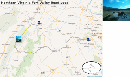
Northern Virginia Fort Valley Road Loop
This is one of our favorite routes through Northern Virginia. We typically start out at 55 where it meets 15 and take side roads down to 17 until it connects to 211.
There's a wonderful section of tight technical but well graded switchbacks on 211 as you approach and cross Skyline Drive.
We usually have lunch in Luray and from there head up to Route 675 which is a series of switchbacks the carves it's way up the side of the mountain. There are wonderful vistas as you go up. Very pretty.
From there you catch Fort Valley Road which goes on seemingly forever as it winds it's way through this magical looking valley of pristine farms and old buildings. It eventually narrows to a tight state park road that follows a roaring creek bordered by steep canyon walls in a deep wood.
We typically make our way to the Starbucks in Front Royal before taking the Superslab back home. Sometimes we'll take 55 for some local color as it winds it's way seemingly through towns that time forgot.
The best sections are tagged in yellow.
Click through to see an interactive version with a description.
Say hello to RTallulah, who works for Competition Accessories and is the author of our latest guest blog post:
RTallulah, who works for Competition Accessories and is the author of our latest guest blog post:
Say hello to Embedded Object Error. 
Sorry the map broke on you. It's still a work in progress and will improve. If you have a chance let me know the steps you took so I can try to reproduce it over here. thanks!
Sorry the map broke on you. It's still a work in progress and will improve. If you have a chance let me know the steps you took so I can try to reproduce it over here. thanks!

Very cool. You'll find that  Yun Lung Yang's bike is virtually identical (and it's currently in my garage next to my Silver '99 'S guest-bike.
I got a notification that you tried to share a map but it looks like it failed. Did it give you an error message or anything? (I've got a huge number of bugs to fix in that code ...)
Yun Lung Yang's bike is virtually identical (and it's currently in my garage next to my Silver '99 'S guest-bike.I got a notification that you tried to share a map but it looks like it failed. Did it give you an error message or anything? (I've got a huge number of bugs to fix in that code ...)
Wow, dude. Is this who I think it is? Say hello to VifferSwiffer. Are you with RevZIlla?
Regardless, welcome to our little site!
VifferSwiffer. Are you with RevZIlla? Regardless, welcome to our little site!
Yes, thats me "CK" from RevZilla, or Chris Kraus as it were!
Loving what I'm seeing with the interactive maps idea. My curiosity persuaded me to join so I could dive into them a bit further.
Also, you guys aren't *too* far away from me in Philly!
-CK
Loving what I'm seeing with the interactive maps idea. My curiosity persuaded me to join so I could dive into them a bit further.
Also, you guys aren't *too* far away from me in Philly!
-CK
wow, welcome! 
The site is very much a work in progress. The maps code is very new and there are quite a few bugs I'm afraid. But I'm working through them. I need to write up some instructions which I'll try to do later today.
You can create a map and click on points then click Calculate Route to get MapQuest Open to calculate a route for you. You can drag the points around if the route they choose isnt' exactly what you want. You can right click on a numbered marker to insert a new one if you need to.
To find places on the map, you can click on the little red pin icon after you select NEW MAP from the Maps list. It's not like Google. You have to enter place name spelled correctly, state name for it to work. (I wish I could use Google but their licensing terms prevent me from doing what I want.)
If you want to route out multiple sections you can right click and select "start new route".
You can also upload a GPX track file from a Garmin GPS and it'll get laid out on the map.
On any route or track you've drawn on the map you can click on the line and it'll give you a menu of options. This allows you to take a segment of a track or route and "tag" it. You can tag an entire route, a section between numbered markers or you can select a start and end point by hand. (You can also delete sections of a track the same way).
For instance, on my Blue RIdge trip I tagged sections of route 28 as especially good.
You can also right click and insert "Points of Interest" to mark places that might be good to go. (Marking RevZilla on the map would be cool. )
)
You can then save out the map. When you click SAVE it tries to generate a screenshot which takes a huge amount of time (same when you click save on a tagged road). I'm working on making that process quicker.
I'll write up more a bit later today. I've been so focused on trying to squash all these bugs that I haven't taken the time to write instructions.
The site is going to be about more than just maps or a greatmotorcycleroads competitor. I really want to turn this into a real interest based social network for motorcycle travelers the encompasses everything from beginning to end ... I'll write something up about that as well.
The site is very much a work in progress. The maps code is very new and there are quite a few bugs I'm afraid.
But I'm working through them. I need to write up some instructions which I'll try to do later today.You can create a map and click on points then click Calculate Route to get MapQuest Open to calculate a route for you. You can drag the points around if the route they choose isnt' exactly what you want. You can right click on a numbered marker to insert a new one if you need to.
To find places on the map, you can click on the little red pin icon after you select NEW MAP from the Maps list. It's not like Google. You have to enter place name spelled correctly, state name for it to work. (I wish I could use Google but their licensing terms prevent me from doing what I want.)
If you want to route out multiple sections you can right click and select "start new route".
You can also upload a GPX track file from a Garmin GPS and it'll get laid out on the map.
On any route or track you've drawn on the map you can click on the line and it'll give you a menu of options. This allows you to take a segment of a track or route and "tag" it. You can tag an entire route, a section between numbered markers or you can select a start and end point by hand. (You can also delete sections of a track the same way).
For instance, on my Blue RIdge trip I tagged sections of route 28 as especially good.
You can also right click and insert "Points of Interest" to mark places that might be good to go. (Marking RevZilla on the map would be cool.
)You can then save out the map. When you click SAVE it tries to generate a screenshot which takes a huge amount of time (same when you click save on a tagged road). I'm working on making that process quicker.
I'll write up more a bit later today. I've been so focused on trying to squash all these bugs that I haven't taken the time to write instructions.
The site is going to be about more than just maps or a greatmotorcycleroads competitor. I really want to turn this into a real interest based social network for motorcycle travelers the encompasses everything from beginning to end ... I'll write something up about that as well.
Awesome, thanks for the info. You guys seem like a tight knit group! Looking forward to learning from your collective knowledge and getting to know some of you better!
 Yermo a ride up to Revzilla should def be put in the near term planning cycle. I want to look at gloves anyway